Your complete guide to Utah’s most spectacular road trips and scenic highways
Utah boasts some of America’s most spectacular scenic drives, winding through landscapes that range from towering red rock canyons to alpine forests, from vast desert vistas to pristine mountain lakes. With 31 designated scenic byways covering over 3,000 miles, Utah offers endless opportunities for unforgettable road trips. Whether you’re planning a quick afternoon drive or a multi-day adventure, these routes showcase the incredible diversity of Utah’s natural beauty.
This comprehensive guide covers 10 of Utah’s most stunning scenic byways, complete with highlights, best stops, driving tips, and ideal travel times. Get ready to discover why Utah is a road tripper’s paradise.
1. Scenic Byway 12: Utah’s Most Diverse Drive
Length: 124 miles
Driving Time: 3-4 hours (allow full day with stops)
Route: Panguitch to Torrey via Bryce Canyon and Grand Staircase-Escalante
Often called one of America’s most beautiful drives, Scenic Byway 12 traverses an astounding variety of landscapes. The route climbs from red rock desert through ponderosa pine forests to alpine meadows, crosses narrow ridgelines with thousand-foot drop-offs on both sides, and winds through Grand Staircase-Escalante National Monument. This designated All-American Road is the only road in the U.S. where every mile is scenic.
Must-See Stops
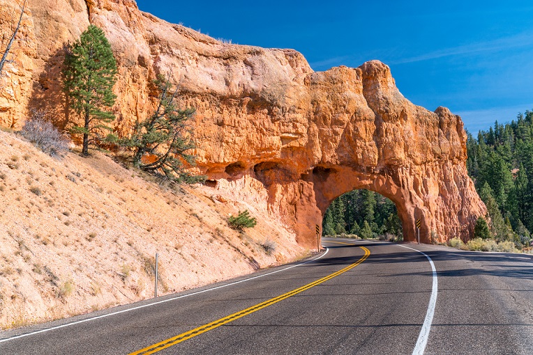
- Red Canyon: Located just before Bryce Canyon, this stunning area features vibrant red rock hoodoos and arches. Stop at the visitor center and walk the short trail under the natural arch that spans the highway.
- Bryce Canyon National Park: While technically a side trip, the park is worth the 17-mile detour to see the otherworldly hoodoos.
- Escalante Petrified Forest State Park: Walk among ancient petrified wood and enjoy views of Wide Hollow Reservoir.
- Head of the Rocks Overlook: Stop at this overlook for panoramic views of the colorful rock formations and distant mountains.
- Hogback Ridge: The most dramatic section of the drive features a narrow ridge with sheer drop-offs on both sides and sweeping views.
- Calf Creek Falls: Hike 6 miles round trip to a spectacular 126-foot waterfall in a desert oasis.
Best Time to Drive
April through October for full access. The route can be driven in winter but expect snow at higher elevations. Spring and fall offer the most comfortable temperatures, while summer brings wildflowers to the alpine sections.
2. Mirror Lake Scenic Byway: Alpine Beauty
Length: 42 miles
Driving Time: 1.5 hours (allow 3-4 hours with stops)
Route: Kamas to Mirror Lake via Highway 150
This spectacular drive climbs from the Heber Valley into the heart of the Uinta Mountains, Utah’s only major east-west mountain range. The route rises from 6,500 feet to over 10,700 feet at Bald Mountain Pass, passing dozens of pristine alpine lakes, wildflower meadows, and dramatic granite peaks. It’s one of the highest paved roads in Utah and offers a completely different experience from the state’s famous red rock drives.
Must-See Stops
- Trial Lake: A beautiful alpine lake with camping and fishing, surrounded by lodgepole pine forest.
- Bald Mountain Pass: The high point of the drive offers sweeping views of the Uinta Mountains. Consider hiking the Bald Mountain Trail for even better views.
- Mirror Lake: The namesake lake offers stunning reflections of the surrounding peaks. Walk the easy 1.5-mile loop trail around the lake.
- Ruth Lake Overlook: Short walk to views of this gorgeous turquoise alpine lake.
Best Time to Drive
Late June through September only—the road closes in winter due to heavy snow. Peak wildflower season is late July. Fall colors appear in late September with golden aspens at lower elevations.
3. Highway 128: Colorado River Scenic Byway
Length: 44 miles
Driving Time: 1 hour (allow 2-3 hours with stops)
Route: Moab to I-70 along the Colorado River
This stunning drive follows the Colorado River through a dramatic red rock canyon, passing towering sandstone cliffs, natural arches, and unique rock formations. The route is particularly beautiful in morning or evening light when the red rocks glow. It’s also a gateway to Castle Valley, one of Utah’s most photogenic landscapes with massive buttes rising from the valley floor.
Must-See Stops
- Fisher Towers: Turn off to view these dramatic spires of dark red rock. The 4.4-mile hiking trail offers closer access.
- Castle Valley Overlook: Stop for views of Castleton Tower and the surrounding buttes that make this valley iconic.
- Negro Bill Canyon: Hike 4 miles round trip to Morning Glory Bridge, one of Utah’s largest natural bridges.
- Red Cliffs Lodge: Stop for lunch or wine tasting at this scenic resort with movie memorabilia from films shot in the area.
Best Time to Drive
Year-round, though summer can be extremely hot. Spring and fall offer the most comfortable temperatures. Sunset drives are particularly spectacular when the rocks glow orange and red.
4. Logan Canyon Scenic Byway (Highway 89)
Length: 41 miles
Driving Time: 1 hour (allow 2-3 hours with stops)
Route: Logan to Bear Lake via Logan Canyon
Logan Canyon offers one of Utah’s most beautiful mountain drives, following the Logan River as it cuts through towering limestone cliffs. The route climbs from the Cache Valley through narrow canyon walls to the summit, then descends to stunning Bear Lake, known as the Caribbean of the Rockies for its brilliant turquoise waters. The drive offers excellent opportunities for hiking, fishing, and rock climbing.
Must-See Stops
- Wind Caves Trail: A popular 1.8-mile hike to unique honeycomb caves with excellent views of the canyon.
- Ricks Spring: Short walk to a crystal-clear spring flowing from the limestone cliffs.
- Bear Lake Overlook: Stop at the summit for your first views of Bear Lake’s incredible blue-green waters.
- Bear Lake State Park: Visit the lake’s beaches and try a famous Bear Lake raspberry shake.
Best Time to Drive
Year-round access. Fall is particularly spectacular with golden aspens lighting up the canyon walls. Winter offers scenic snow-covered landscapes. Summer provides access to all hiking trails and water activities at Bear Lake.
5. Zion-Mount Carmel Highway (Highway 9)
Length: 24 miles
Driving Time: 45 minutes (allow 2-3 hours with stops)
Route: Springdale to Mount Carmel Junction through Zion National Park
This engineering marvel passes through Zion National Park, featuring the famous 1.1-mile Zion-Mount Carmel Tunnel completed in 1930. The route offers completely different perspectives of Zion than the main canyon, showcasing cream and peach colored Navajo sandstone slickrock formations. The eastern section reveals Checkerboard Mesa and other fascinating geological features.
Must-See Stops
- Canyon Overlook Trail: A 1-mile round trip hike just east of the tunnel offering spectacular views of lower Zion Canyon and Pine Creek Canyon.
- Checkerboard Mesa: Stop at the pullout to photograph this distinctive crosshatched sandstone formation.
- The Zion-Mount Carmel Tunnel: The historic tunnel itself features windows carved into the canyon walls. Large vehicles require ranger escort and additional fees.
Best Time to Drive
Year-round access. Morning light is particularly beautiful on the eastern section’s white and cream colored rocks. Requires Zion National Park entrance fee.
6. Nebo Loop Scenic Byway
Length: 38 miles
Driving Time: 1.5 hours (allow 3-4 hours with stops)
Route: Payson to Nephi via Mount Nebo
This spectacular mountain loop winds around the tallest peak in the Wasatch Range, climbing to over 9,000 feet. The route offers stunning alpine scenery, sweeping valley views, and some of Utah’s best fall colors. Dense aspen groves turn brilliant gold in late September, making this one of the most popular fall drives in the state. The road is well-maintained but narrow and winding in places.
Must-See Stops
- Payson Lakes: A cluster of scenic mountain lakes with camping and fishing opportunities.
- Grotto Falls: Short walk to a beautiful waterfall cascading into a natural grotto.
- Devil’s Kitchen Overlook: Stunning views of unique red rock formations contrasting with the green mountain slopes.
- Mount Nebo Trailhead: Access point for hiking to the summit of Mount Nebo, the highest peak in the Wasatch Range at 11,928 feet.
Best Time to Drive
Late May through October. The road closes in winter. Peak fall colors typically occur during the last week of September and first week of October. Summer offers wildflower meadows and comfortable temperatures.
7. Flaming Gorge-Uintas Scenic Byway (Highway 44)
Length: 67 miles
Driving Time: 1.5 hours (allow 3-4 hours with stops)
Route: Manila to Vernal via Flaming Gorge
This remote scenic drive connects Flaming Gorge National Recreation Area with Vernal, passing through diverse landscapes from deep red canyons to alpine forests. The route offers spectacular views of the Green River cutting through massive red rock cliffs in Flaming Gorge, then climbs into the eastern Uinta Mountains before descending to the desert basin. Wildlife viewing opportunities include elk, deer, and birds of prey.
Must-See Stops
- Red Canyon Overlook: Dramatic views of the Green River winding through towering red cliffs 1,400 feet below.
- Flaming Gorge Dam: Tour the dam and visitor center to learn about the reservoir’s creation and hydroelectric power generation.
- Sheep Creek Canyon Geological Loop: A short side trip offering incredible geology including exposed rock layers spanning billions of years.
- Red Fleet State Park: Stop to see dinosaur tracks preserved in sandstone along the reservoir shore.
Best Time to Drive
May through October for full access to side roads. Summer offers warm weather for water activities at Flaming Gorge. Fall brings beautiful colors and comfortable driving conditions.
8. Moab to Monticello Scenic Byway (Highway 191)
Length: 54 miles
Driving Time: 1 hour (allow 2-3 hours with stops)
Route: Moab to Monticello via Wilson Arch and Newspaper Rock
While less famous than other Utah scenic drives, this route offers surprising diversity and several notable attractions. The road climbs from Moab’s red rock desert through juniper and pinyon pine country to the cooler, forested Abajo Mountains near Monticello. The highlight is Newspaper Rock, featuring one of the most impressive collections of ancient petroglyphs in the Southwest.
Must-See Stops
- Wilson Arch: A large natural arch visible from the highway with a short walk for better views.
- Newspaper Rock: An incredible concentration of petroglyphs created over 2,000 years by various cultures. Free to visit with interpretive signs.
- Canyonlands Field Airport Overlook: Pull off for expansive views of red rock country stretching toward Canyonlands National Park.
Best Time to Drive
Year-round access. Spring and fall offer the most comfortable temperatures. This route works well as a connector between Moab and destinations further south.
9. Big Cottonwood Canyon Scenic Byway
Length: 19 miles
Driving Time: 30 minutes (allow 1-2 hours with stops)
Route: Salt Lake Valley to Brighton Resort via Highway 190
Just 30 minutes from downtown Salt Lake City, Big Cottonwood Canyon offers a quick escape into pristine mountain scenery. The route follows Big Cottonwood Creek as it tumbles through a narrow granite canyon flanked by towering peaks. The canyon is home to two world-class ski resorts and provides year-round outdoor recreation. Fall brings spectacular displays of red, orange, and gold as maples and aspens change color.
Must-See Stops
- Donut Falls: Popular 1.5-mile hike to a unique waterfall that drops through a hole in the rock.
- Silver Lake at Brighton: Beautiful alpine lake with an easy boardwalk loop trail offering mountain reflections and wildflowers in summer.
- Storm Mountain Picnic Area: Scenic spot along the creek perfect for a roadside break.
Best Time to Drive
Year-round access but bring snow tires or chains in winter. Late September through early October offers peak fall colors. Summer provides access to hiking trails and high alpine lakes.
10. Patchwork Parkway (Highway 12 South)
Length: 55 miles
Driving Time: 1.5 hours (allow 3 hours with stops)
Route: Panguitch to Junction via Hatch and Red Canyon
Named for the scenic patchwork of forests, fields, and rock formations along the route, this lesser-known drive offers beautiful mountain scenery without the crowds. The route passes through charming small towns, climbs through pine forests, and offers distant views of colorful rock formations. It’s particularly beautiful in fall when aspen groves turn gold against red rock backgrounds.
Must-See Stops
- Panguitch Lake: Popular fishing destination with scenic mountain views and camping facilities.
- Historic Panguitch: Charming small town with well-preserved pioneer architecture and antique shops.
- Red Canyon: Often called Little Bryce Canyon for its miniature hoodoos and bright red rocks.
Best Time to Drive
Late May through October. Fall colors peak in late September. The route can be snowy in winter months.
Essential Tips for Utah Scenic Drives
Vehicle Preparation
- Check your spare tire and know how to change it—cell service is limited
- Fill up with gas before starting—many routes have limited services
- Bring extra water and snacks for the journey
- Download offline maps before you leave
Driving Safety
- Use pullouts for photography—never stop in the road
- Watch for wildlife, especially at dawn and dusk
- Mountain roads can be narrow and winding—drive cautiously
- Check weather and road conditions before high-elevation drives
Photography Tips
- Golden hour (first and last hour of daylight) provides the best light for red rock landscapes
- Polarizing filters reduce glare and enhance colors
- Include foreground elements for depth in landscape photos
- Scout locations in advance and arrive early for popular spots
Best Seasons for Scenic Drives
Spring (March-May): Wildflowers bloom, waterfalls flow strong, temperatures are comfortable. Some high-elevation roads may still be closed.
Summer (June-August): All roads open, best time for high-elevation drives. Desert routes can be extremely hot. Expect crowds at popular destinations.
Fall (September-October): Peak season for many routes. Spectacular fall colors, comfortable temperatures, fewer crowds than summer. Book accommodations early.
Winter (November-February): Many high-elevation roads closed. Desert drives offer solitude and beautiful snow-dusted landscapes. Check road conditions carefully.
Combining Multiple Scenic Byways
Many of Utah’s scenic byways can be combined into epic road trips. Consider these combinations:
- Mighty 5 Loop: Combine Highway 12, Highway 24 through Capitol Reef, Highway 128, and Highway 191 to connect all five national parks
- Northern Utah Circuit: Link Mirror Lake Byway with Logan Canyon for a spectacular mountain loop
- Weekend Getaway: Pair Zion-Mount Carmel Highway with Highway 12 for an incredible 2-3 day road trip
Utah’s scenic byways showcase the incredible diversity of the state’s landscapes, from alpine peaks to red rock deserts, from narrow canyons to vast valleys. Whether you have a few hours or several days, these spectacular drives offer unforgettable experiences and photo opportunities at every turn. Pack your camera, fill up the tank, and discover why Utah is one of America’s premier road trip destinations.
For more Utah travel inspiration, explore our guides to national parks, hiking trails, and hidden gems on the Discover Utah blog.